
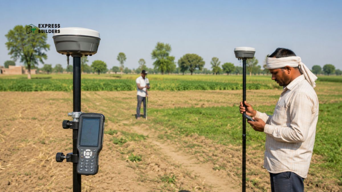
Uttar Pradesh has launched a new land measurement drive called Digi Rover Drive UP. The state government rolled out this campaign to fix pending land disputes. It uses advanced GNSS based Digi Rover technology for accurate results. This move replaces old measuring chains with modern satellite tools. Landowners across the state can now expect faster and fairer outcomes. This blog explains what Digi Rover Drive UP means for property owners. It also covers how Digi Rover technology works on the ground. You will also learn why Land Measurement accuracy matters so much today. The shift toward satellite based surveys marks a significant policy change. It reflects a broader effort to modernise land governance across India. Understanding this shift helps every landowner prepare for coming changes.
What Is Digi Rover Drive UP
Uttar Pradesh Govt launches Special Land Measurement Campaign
READ: https://t.co/K9JakZL9fR pic.twitter.com/Bqbp1h4oCj
— All India Radio News (@airnewsalerts) July 2, 2026
Digi Rover Drive UP is a statewide land measurement campaign. The Uttar Pradesh government launched it to clear pending demarcation cases. Every tehsil across the state will use Digi Rover GNSS technology. Officials aim to resolve all pending land measurement disputes quickly. This campaign runs for a fixed period across every district. Revenue officials, district magistrates, and divisional commissioners are overseeing the process. The goal is a transparent and technology driven land record system. Farmers and landowners no longer need repeated visits to government offices.
The campaign was launched with a clear message from state leadership. Officials stressed that traditional survey methods no longer suit modern needs. Growing populations and shrinking plot sizes make precise boundaries essential. Every additional inch of disputed land can trigger years of conflict. Digi Rover Drive UP directly addresses this long standing rural problem. The state hopes to set a benchmark for other regions to follow.
Traditional land measurement in India relied on physical chains and tapes. These methods often produced errors due to human handling. Small errors led to boundary disputes between neighbouring landowners. Many disputes dragged on for years without clear resolution. Court cases over a few feet of land are still common. Families sometimes spend more on legal fees than the land is worth. Digi Rover technology aims to remove this margin of error entirely. Satellite based measurement gives each plot a precise digital boundary. This reduces confusion and prevents future disagreements between landowners.
Understanding Digi Rover Technology
Digi Rover uses GNSS, or Global Navigation Satellite System, for positioning. GNSS includes signals from GPS, GLONASS, Galileo, and other satellite networks. A Digi Rover device receives these signals directly in the field. It calculates exact coordinates for every corner of a plot. This process removes the guesswork found in manual measurement methods. The system can also use a base and rover setup. A stationary base station receives satellite signals from a known point. The rover moves across the field and receives the same signals. Comparing both readings gives centimetre level accuracy for each point. This method is called Real Time Kinematic, or RTK, positioning. RTK technology is already common in modern surveying and construction work.
A trained operator carries the Digi Rover device across the plot. The device marks each boundary point with precise coordinates. These coordinates get recorded directly into a digital land record. This removes paperwork delays common with older measurement systems. Landowners can view their updated records once the survey finishes. The entire process takes far less time than manual chain surveys. It also leaves little room for manipulation or recording errors.
Digi Rover devices also work well in difficult field conditions. Uneven terrain, small lanes, and crowded villages no longer slow surveys down. Operators can move quickly between points without losing measurement accuracy. This flexibility makes the technology suitable for both farmland and urban plots. Even plots with unclear historical boundaries can now get resurveyed accurately. The system also reduces dependency on the physical skill of the surveyor. Earlier, results varied depending on who held the measuring chain. Digi Rover keeps results consistent no matter who operates the device.
Comparing Traditional Methods with Digi Rover
Traditional chain based measurement required at least two or three people. It also demanded clear, obstacle free lines across the entire plot. Trees, structures, or slopes often disrupted accurate chain measurement badly. Digi Rover needs only one trained operator for most surveys. It does not require a clear line of sight across the plot. Satellite signals reach the device from almost any open position. This makes surveys faster, cheaper, and far more dependable overall. Older methods also left more room for disputes over readings. Digital coordinates leave a permanent, verifiable record of each boundary. This transparency benefits both landowners and government revenue departments equally.
Why Land Measurement Accuracy Matters
Land Measurement accuracy affects every property transaction in the state. Incorrect boundaries can delay sales, mortgages, and inheritance transfers. Many rural disputes start with unclear or contested plot boundaries. Farmers often lose valuable time fighting over a few feet of land. Accurate measurement protects the rights of every legitimate landowner. It also helps government departments plan infrastructure and irrigation projects better. Clear records support faster processing for loans against agricultural land. Buyers gain confidence when a plot has a verified digital boundary. This confidence supports healthier property markets across urban and rural areas.
Land Measurement has also evolved alongside changing legal requirements. Courts increasingly expect digital evidence for boundary related disputes. A GNSS verified boundary carries more weight than an old paper record. This shift pushes state governments toward full digitisation of land records. Digi Rover Drive UP fits directly into this larger digital push.
Accurate Land Measurement also supports better tax and revenue collection. Government departments can assess land value more fairly with correct data. Incorrect plot sizes sometimes lead to under assessment or over assessment. Digi Rover data helps correct these long standing record mismatches. This benefits both individual landowners and overall state revenue planning.
How Digi Rover Drive UP Benefits Farmers
Farmers form the largest group affected by this measurement campaign. Many farming families have waited years for boundary disputes to resolve. Digi Rover technology speeds up this entire resolution process significantly. Farmers receive accurate plot boundaries without hiring private surveyors. This saves both money and repeated trips to revenue offices. Clear boundaries also help farmers access institutional loans more easily. Banks prefer lending against land with verified and undisputed records. Reduced disputes mean farmers spend more time on actual cultivation. Families avoid long standing tensions with neighbouring landowners as well.
The campaign also protects farmers from encroachment on their land. Precise coordinates make illegal encroachment far easier to detect. Revenue officials can compare current boundaries against recorded coordinates instantly. This transparency discourages future attempts at boundary manipulation. Farmers gain lasting security over their rightful land holdings.
Inherited farmland often carries the most confusing boundary history. Multiple generations may have divided a single plot informally. Digi Rover surveys help formalise these divisions with clear coordinates. This prevents disputes among siblings and extended family members later. Clear digital records also simplify future inheritance and partition processes.
Impact on Urban Property Owners
Urban landowners also benefit from accurate digital land measurement. Many urban plots face boundary confusion due to old paper records. Digi Rover technology helps clarify these boundaries with satellite precision. This supports smoother property registration and transfer processes in cities. Buyers can verify plot dimensions before finalising any purchase decision. Accurate records also reduce the chances of future legal disputes. Developers benefit from clear boundaries when planning new residential projects. Clear land records support faster approvals from local development authorities.
Property buyers should always check current land records before purchasing. Digi Rover verified boundaries add another layer of buyer confidence. This is especially useful in fast growing areas of the state. Rapid urban expansion often creates overlapping or unclear property claims. Digital measurement helps prevent such overlaps from causing future problems.
Growing towns near major highways face the highest boundary confusion. Rapid land conversion from agricultural to residential use complicates records. Digi Rover surveys help update these records as land use changes. This keeps government records aligned with actual, current land conditions. Buyers researching plots in expanding areas benefit greatly from this accuracy.
Read More: UP Bhulekh
How the Campaign Is Being Implemented
The state government directed officials to run this campaign seriously. District magistrates and divisional commissioners are monitoring daily progress closely. Every tehsil received specific targets for pending case resolution. Revenue teams are prioritising long pending demarcation and boundary cases first. Officials are using Digi Rover devices across rural and urban tehsils. The government wants complete transparency throughout the measurement process. Citizens can track the status of their own pending cases. This accountability builds public trust in the overall land record system.
Officials also plan public awareness sessions in affected villages and towns. These sessions explain how landowners can request a Digi Rover survey. Citizens learn what documents they need for the process. This outreach ensures more people benefit from the campaign directly. Wider participation supports the larger goal of dispute free land records.
Field teams are also being trained specifically for Digi Rover operations. Training covers device handling, coordinate recording, and dispute documentation. Well trained operators reduce the chances of measurement errors on site. This preparation helps the campaign move faster across every district. Officials review completed cases regularly to maintain consistent quality standards.
Comparing Traditional Methods with Digi Rover
| Aspect | Traditional Chain Method | Digi Rover Method |
| Staff Required | Two to three people | One trained operator |
| Line of Sight | Must be clear and obstacle-free | Not required |
| Affected by Trees, Structures, and Slopes | Yes, often disrupted | No |
| Speed | Slow | Fast |
| Accuracy | Prone to human error | Centimetre-level precision |
| Record Type | Paper-based | Digital, verifiable coordinates |
| Dispute Risk | Higher | Lower |
Digi Rover and the Future of Land Records
Digi Rover Drive UP represents a larger shift toward digital governance. Uttar Pradesh has already digitised many land record systems in recent years. Portals for viewing khatauni, khasra, and mutation records already exist. Digi Rover adds precise spatial data to these existing digital records. Together, these systems create a complete digital picture of land ownership. Future property transactions may rely entirely on these verified digital records. This reduces dependency on physical documents that can get lost or damaged. It also makes land records accessible from anywhere with an internet connection.
Other states may adopt similar GNSS based measurement systems over time. Accurate spatial data supports better urban planning and infrastructure decisions. Government agencies can use this data for tax assessment as well. Insurance companies may also use verified boundaries for property coverage decisions. The long term impact of Digi Rover extends well beyond dispute resolution.
As digital land records mature, integration with other services will grow. Building approvals, utility connections, and irrigation planning could use this data. A single, reliable source of spatial truth benefits many government functions. This long term vision positions Uttar Pradesh as a digital governance leader.
Reducing Corruption Through Digital Measurement
Manual land measurement historically left room for local manipulation. A few landowners sometimes influenced surveyors to shift boundary lines slightly. Digi Rover technology removes this human influence from the process. Satellite coordinates cannot be altered by local pressure or bias. This builds greater trust between citizens and revenue departments. Officials also benefit from clear digital trails for every survey conducted. Any future disputes can be checked against original recorded coordinates. This accountability discourages future attempts at unfair boundary changes.
Digital records also make audits and reviews far simpler for officials. Supervisors can verify field data without visiting every single site. This oversight improves consistency across different districts and tehsils. Citizens gain confidence knowing their records follow the same standard everywhere.
Supporting Infrastructure and Development Planning
Accurate land data supports far more than individual property disputes. Road widening projects need precise boundary information before construction begins. Irrigation canals and drainage systems also depend on correct plot data. Digi Rover surveys give planners reliable data for these larger projects. This reduces delays caused by unclear or disputed land records. Development authorities can plan new residential zones with greater confidence. Clear boundaries also help avoid unnecessary compensation disputes during acquisition. Overall, accurate Land Measurement supports stronger regional planning outcomes.
Public infrastructure projects often stall due to unresolved land conflicts. Digi Rover Drive UP directly reduces this common source of delay. Faster boundary resolution means faster approvals for public works projects. This benefits entire communities waiting for improved roads and utilities.
Steps Landowners Should Take Now
Landowners should first check if their area falls under this campaign.
- Visiting the local tehsil office provides the latest campaign updates.
- Keep existing property documents ready before requesting a Digi Rover survey. This includes sale deeds, khatauni copies, and any prior survey records.
- Cooperating with field officials speeds up the entire measurement process.
- Landowners should verify new coordinates once the survey gets completed.
- Reporting any discrepancy early prevents future complications with property records.
- Staying informed helps landowners make the most of this initiative.
It also helps to inform neighbouring landowners about upcoming surveys. Shared boundaries often need agreement from both sides during demarcation. Cooperative neighbours can resolve minor disagreements before officials even arrive. This proactive approach speeds up the survey and reduces future friction.
Common Land Measurement Terms to Know
Understanding basic terms helps landowners follow the process more easily. Khasra refers to the survey number assigned to a specific plot. Khatauni is the record showing ownership details for that plot. Demarcation means marking the exact boundary lines of a property. GNSS stands for the satellite network used for positioning data. RTK refers to the real time correction method for precise readings. Knowing these terms makes interactions with revenue officials much smoother. Familiarity with these basics also helps during property registration and mutation. Landowners who understand these terms can spot errors in their records faster. This small effort often saves considerable time during future transactions.
Beyond these terms, landowners should also understand basic Land Measurement units. Local units like bigha and biswa still appear in older records. Digi Rover surveys convert these into standard metric measurements automatically. This standardisation makes comparing plots across regions much easier. It also simplifies documentation for banks, buyers, and government departments.
Final Thoughts
Digi Rover Drive UP marks a meaningful step toward accurate land records. It replaces outdated measurement methods with reliable satellite technology. Farmers and urban landowners both stand to gain from this shift. Faster dispute resolution and clearer boundaries benefit the entire state. As digitisation expands, property transactions should become simpler and safer. Staying updated on such initiatives helps landowners protect their assets better. Accurate Land Measurement today builds a stronger foundation for tomorrow.
Explore homes designed around trusted planning and transparent documentation with Express Builder. With decades of experience across Noida, Greater Noida West, and Ghaziabad, Express Builder delivers well planned residential projects. Book a site visit today and see why families choose Express Builder for their next home.
Frequently Asked Questions
What is Digi Rover Drive UP?
It is a statewide campaign using GNSS technology for accurate land measurement across Uttar Pradesh.
How does Digi Rover technology improve accuracy?
It uses satellite signals and RTK positioning to measure plot boundaries with centimetre level precision.
Who benefits most from this campaign?
Farmers and landowners with pending boundary disputes benefit the most from faster resolution.
Do landowners need to pay for a Digi Rover survey?
The campaign is run by the state government to resolve pending cases at no extra cost.
